Rural Practical Skills (Edexcel IGCSE Geography)
Spec point —
4GE1-S9.128
Aims, sampling, equipment & risk assessment
Rural environment fieldwork enquiry
-
To undertake the rural fieldwork enquiry there are a range of practical skills and methods that will be used
-
These can apply to any rural fieldwork
-
The fieldwork enquiry should be linked to geographical theory
- In the rural fieldwork enquiry, the theories of counter-urbanisation can be linked to rural environmental change
Aims and hypothesis
-
The aims and hypothesis come from the questions asked about the change in rural environments, such as:
- What impact on the rural environment does the building of a new housing estate/road/industrial estate have?
- How has the land use in [specified location] changed?
-
Examples of an aim would be:
- An investigation into the environmental impact of a new road/housing estate/business park in [specified location]
- An investigation into changes in land use in [specified location]
-
Examples of hypotheses:
- The building of [specified location] housing estate has had a negative impact on the environment
- The changing land use in [specified location] has negatively impacted the local environment
-
After the aims and hypothesis have been established, the next steps include:
- Selecting the sites – this will involve sampling
- Deciding on the equipment to be used
- Considering any health and safety issues – completing a risk assessment
- Deciding on data collection methods
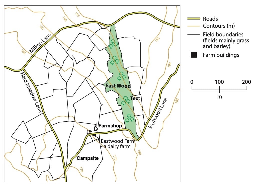
Worked Example Study Figure 1, which shows a map extract of a farm
**Suggest two possible geographical aims for an investigation of this rural area **
(2 Marks)
Answer:
- Changing land use on the farm (1)
- The impact of changing land use on the environment** (1)**
Site selection and sampling
-
It is not practical to take measurements or look at changes in all parts of the rural environment
-
To select sites sampling should be used
-
Sampling will:
- Reduce bias
- Provide an overview of the whole
-
There may be situations where access to the sample site may be limited, meaning an opportunistic approach may need to be taken
- This should be as close as possible to the site selected using sampling
-
The most commonly used sampling strategies for a rural environment enquiry are:
- Systematic- sampling of sites/people at regular intervals along a transect line
- Random- all sites have an equal chance of being selected. A grid is placed across the rural area to be sampled
- Stratified- sampling sites which represent the whole. If 10% of the population is over 65, then 10% of a questionnaire sample should be over 65
-
Site location can be recorded using GPS to give an accurate location using latitude and longitude
Worked Example You have studied rural environments as part of your own geographical enquiry
**State one type of sampling you used in your geographical enquiry **
(1 Mark)
Answer:
- Systematic (1)
- Stratified (1)
- Random (1)
- Opportunistic (1)
Explain one way that this method helped you to collect reliable data or information.
(2 Marks)
Answer:
- Systematic sampling was used at regular intervals (1) so that we knew that we would get good spatial coverage to minimise bias (1)
- Stratified sampling was used as we had census data about the village population (1) so we could design a fair sampling frame for the questionnaire about the impact on the environment that we were using** (1)**
- Random sampling was used as all sites have an equal chance of being selected (1). This minimises bias (1)
- Opportunistic sampling was used as some of the sample sites could not be accessed (1). This meant the nearest accessible sites had to be used for data collection (1)
Equipment
-
To complete the rural environments enquiry a range of equipment is needed
-
The equipment needed may include the following:
- Record sheets
- Interview Sheets
- Pencil for completing recording sheets
- Camera to take photographs of land use
- Digital noise meter
- Environmental Quality Surveys
- Maps
Risk assessment
-
Any fieldwork will involve consideration of health and safety using a risk assessment
-
Risks specifically associated with rural environment fieldwork may include:
- Weather conditions
- Uneven ground
- Working in an unfamiliar place
- Traffic
- Livestock
Worked Example **Explain one way you managed a risk associated with your primary data collection **
(2 Marks)
Answer: **1 mark will be awarded for identifying the risk and a second mark for developing the answer to explain how the risk was managed
- In the rural area, there was a lot of farm traffic so the risk was being struck by a vehicle (1). This was managed by only walking on pavements and using designated crossings (1)
- Fieldwork was carried out in summer so there was a slight chance of sunburn and heatstroke (1) Appropriate clothing was worn, suncream applied and water drunk regularly (1)
- The uneven ground in rural areas poses a risk of slipping or falling** (1)** Appropriate footwear was worn with good treads (1)
- Livestock in fields poses a risk to people entering the fields** (1).Only fields where there was no livestock were entered (1)
Equipment for Investigating Rural Environments
Spec point —
4GE1-S9.128
Using equipment in the field
-
The data collection methods depend on the aims/hypothesis of the fieldwork
- In rural environment fieldwork, the only equipment which may be used is a digital decibel meter
- Other data collection may include questionnaires, traffic counts and environmental quality surveys
-
Data collection should include both quantitative and qualitative methods
Questionnaires
-
Questionnaires can be used to gather the opinions of local people on changes in the rural environment
-
An example of a statement question would be:
- 'The building of the new housing estate has increased traffic.' Do you strongly agree, agree, disagree or strongly disagree?
-
An example of a closed question would be:
- 'How long have you lived in this area?'
-
An example of an open question would be:
- 'What are your views on the new housing development in ............?'
-
-
These can be used to gather a large data sample
Environmental quality surveys
-
Environmental Quality Surveys (EQS) can be used to compare different sites within the rural area
- A survey would be completed for each site
- Care needs to be taken to be as objective as possible
| Feature | Negative | -2 | -1 | 0 | 1 | 2 | Positive |
|---|---|---|---|---|---|---|---|
| Pavements | Pavements damaged and cracked in a poor state of repair | Good quality pavements in excellent state of repair | |||||
| Buildings | Buildings look derelict and uncared for | Buildings look well cared for | |||||
| Litter | Lots of litter | No litter | |||||
| Traffic | Lots of traffic and congestion | No traffic | |||||
| Green space | No green space, trees or vegetation | Lots of green space, trees and other vegetation | |||||
| Graffiti | Lots of graffiti | No graffiti |
Traffic and pedestrian flow surveys
- Traffic and pedestrian flow surveys can be used to compare the traffic and pedestrian levels at different sample sites
- They can be completed on a tally chart at different sites and at different times of the day
| Vehicle | 9am | 11am | 1pm | 3pm |
|---|---|---|---|---|
| Car | ||||
| Bus | ||||
| Lorry | ||||
| Motorbike | ||||
| Bicycle |
Worked Example **Identify one type of quantitative data used in a rural environment land use change enquiry **
(1 mark)
Answer:
- Photos and sketches (1)
- Information from newspapers/websites (1)
- Open-ended questions from questionnaires** (1)**
- Interview answers (1)
Photographs and field sketches
- Photographs and field sketches are qualitative data
- Just as with any data collection and presentation, they have their strengths and weaknesses
- In a rural environment, enquiry photographs and field sketches can be used to show changes in land use and impact on the environment at sample site locations
- Photographs are also useful for illustrating the data collection methods used
Worked Example Explain why field sketches are a useful form of primary data
(2 Marks)
Answer: **
- Can capture lots of detail (1) which means they can be examined properly after the field trip has ended (1)
- Highlights specific features which relate to the other data collected**(1) so can be used to support other forms of data collection (1)
- Easy to annotate to show details (1) so can help with analysis (1).
Exam Hint Annotations and labels are not the same. A label is a simple descriptive point. For example, 'litter'. Whereas an annotation is a label with a more detailed description or explanatory point. For example, Large amounts of litter near to a playground where there are no bins available.
Was this revision note helpful?