Types of Hazards (Edexcel IGCSE Geography)
Anatomy of Natural Hazards
Spec point —
4GE1-S3.044
Natural hazards
-
A hazard is an event which has the potential to cause harm to the environment, people or the economy
-
A natural hazard is an event caused by environmental processes
-
A disaster occurs when harm actually occurs to the environment, people or the economy
-
Natural hazards can be categorised by their causes
-
Tectonic and geological hazards include:
- earthquakes, volcanic eruptions, landslides and tsunami
-
Climate and meteorological hazards include:
- Drought
- Blizzard/snowstorm/sandstorm
- Heatwave
- Tornado/cyclone
- Wildfire/forest fire
- Extreme rainfall/flash flood caused by extreme rainfall
- Severe storm/thunderstorm
-
Biological hazards include:
- pests and diseases
-
-
Natural events only become hazards and disasters due to their impact on people, the environment or the economy
-
Natural hazards can also be categorised in a range of other ways:
- Magnitude - the strength/power of the event
- **Frequency **- how often the event occurs
- Size - the area covered by the hazard
- Duration - the time a hazard event lasts
- Location - where a hazard event occurs
-
Hazard** risk r**efers to the likelihood of an event causing harm to people, the environment or the economy
-
Different locations have different levels of vulnerability
- This refers to location features which affect how susceptible an area is to a hazard event
Tropical cyclones
-
Tropical cyclones are rotating, low-pressure systems (below 950mb)
-
They are known as hurricanes, cyclones and typhoons in different areas of the world
-
Characteristics include:
- heavy rainfall
- high wind speeds(over 119 kmph)
- high waves and storm surges
-
Measuring between 100-1000km across the rotating clouds surround a central, calm eye
-
The magnitude of tropical cyclones is measured on the Saffir-Simpson Scale from 1 to 5
-
They develop in tropical regions between 5o and 30o north and south of the equator
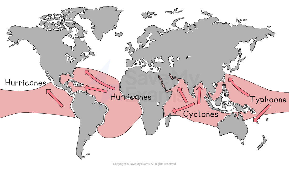
Map showing the global distribution of tropical cyclones
Earthquakes
- An earthquake is a sudden, violent shaking of the ground
- Earthquakes occur at all types of plate boundaries
- Earthquakes are the result of pressure building when tectonic plates move
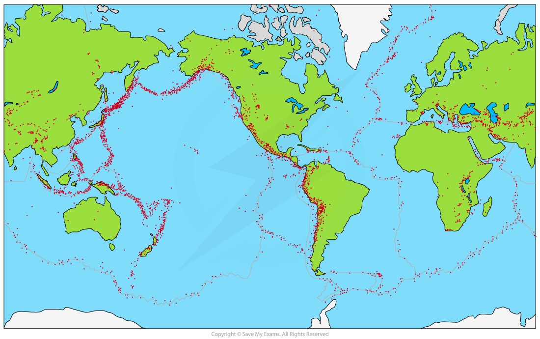
Map showing global earthquake distribution
- The epicentre is the point on the Earth's surface directly above the focus
- The focus is the point at which the earthquake starts below the Earth's surface
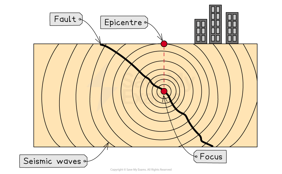
Features of an earthquake
Measuring earthquake magnitude
- The magnitude (strength/power) of earthquakes is measured on either the Richter Scale or the Moment Magnitude Scale
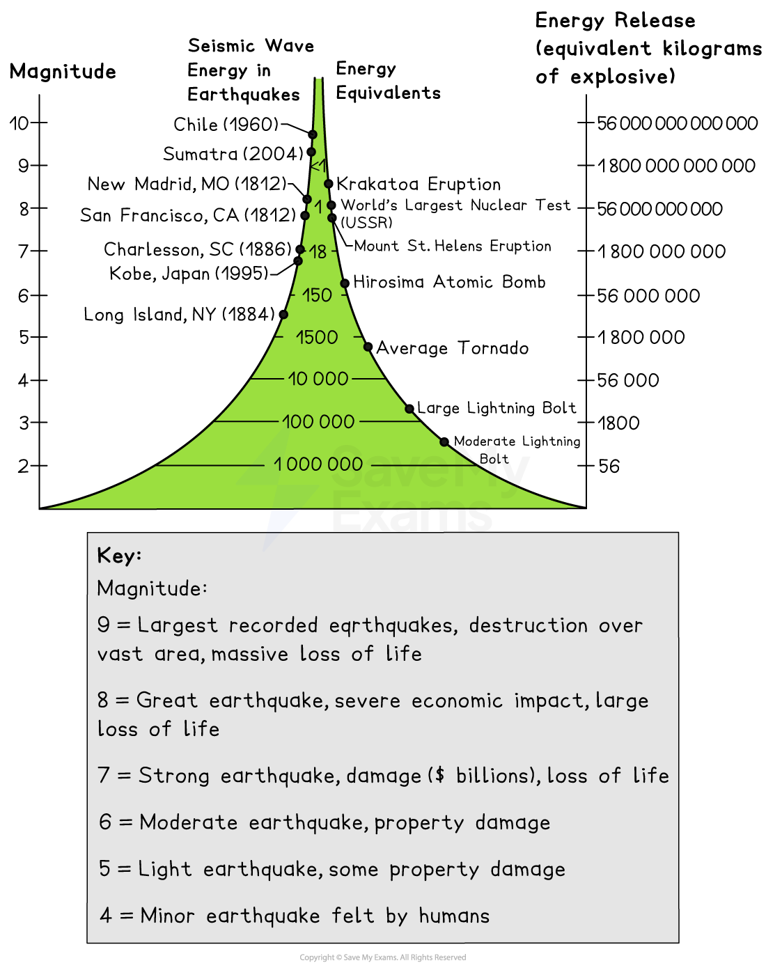
Measuring earthquake magnitude
- The damage caused by earthquakes is measured on the Mercalli Scale
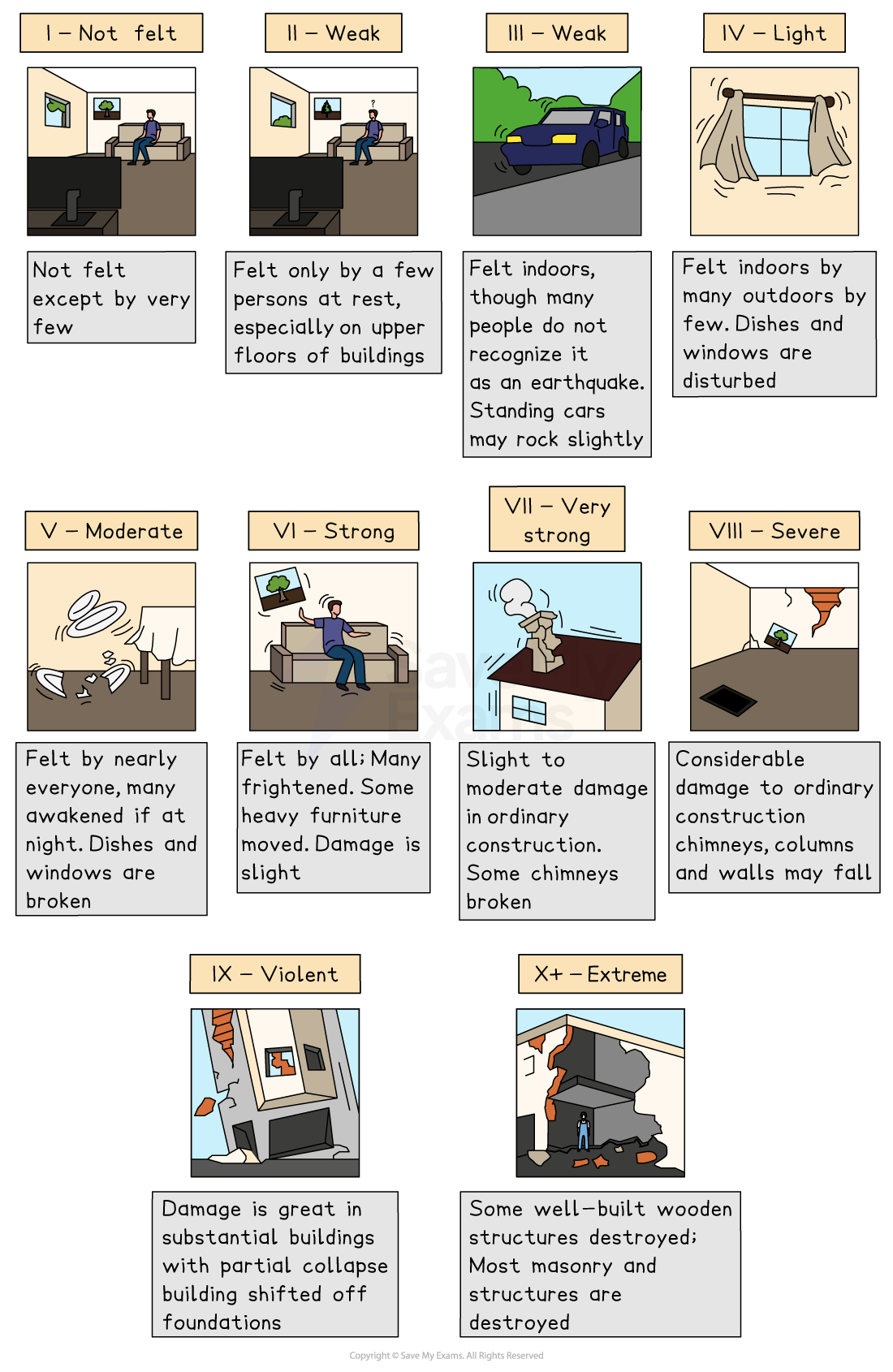
The Mercalli Scale
Volcanoes
- Volcanoes form when magma erupts onto the Earth's surface as lava
- Most volcanoes occur at constructive (divergent) and destructive (convergent) plate boundaries
- The majority of active volcanoes are located around the rim of the Pacific Ocean called the 'Ring of Fire'
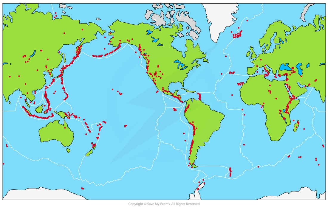
Map showing global volcano distribution
- Hotspots occur away from plate boundaries and are plumes/columns of magma which escape through the Earth's crust
Measuring eruption magnitude
- The magnitude of a volcanic eruption is measured on the Volcanic Explosivity Index (VEI)
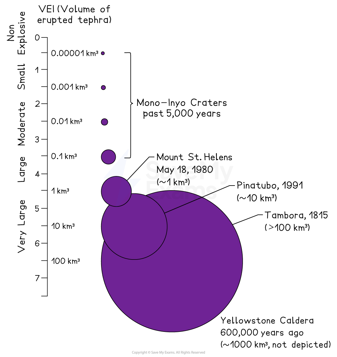
The volcanic explosivity index (VEI)
Exam Hint When describing the distribution of hazards from a map, ask yourself the following questions;
- What is the general pattern?
- Does the pattern relate to anything else for example the location of plate boundaries?
- Are they near the equator or further away?
- Are they inland or coastal?
Use map features to help with your description - place names, compass rose, latitude and longitude
Was this revision note helpful?