Changes in River Characteristics (Edexcel IGCSE Geography)
Spec point —
4GE1-S3.042
Changes in river characteristics
River characteristics
- All rivers have a long profile and cross-profiles
- Each river's long and cross-profiles are unique but they do have some characteristics in common
- These profiles show changes in river characteristics from the source to the mouth
Long profile
-
The long profile of a river shows the changes in the river gradient from the source to the mouth
-
Most long profiles have a concave shape with similar characteristics:
- The source is usually in an upland area
- The **upper course **of the river includes areas which are steep with uneven surfaces
- In the middle course, the gradient decreases
- In the** lower section**, the gradient decreases further until it becomes almost flat
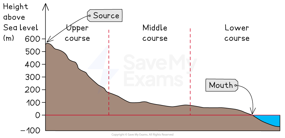
Illustration showing the long profile of a river
Cross profiles
-
The cross profiles of a river are cross-sections from one bank to another
-
Cross profiles of the upper, middle and lower courses show the changes in the river channel
-
Upper course characteristics include:
- Shallow channel
- Steep valley sides
- Narrow channel
- Low velocity
- Large bedload
- Rough channel bed
- High levels of friction
- Vertical erosion
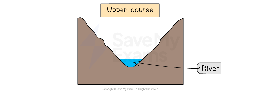
Cross-profile of the upper course of a river
-
Middle course characteristics:
- Deeper than upper course channel
- Gentle valley sides
- Wider than upper-course channel
- Greater velocity than the upper course channel
- Material in the river decreases in size
- Smoother channel bed
- Lower levels of friction than the upper course channel
- Lateral erosion
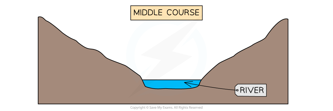
Cross-profile of the middle course of a river
-
Lower course characteristics:
- Deeper than middle course channel
- Flat floodplains
- Wider than middle course channel
- Greater velocity than the middle course channel (apart from as the river enters the mouth)
- Material carried mainly sediment and alluvium
- Smooth channel bed
- Lowest friction
- Deposition is dominant

Lower Course
Exam Hint Remember valley shape and river shape are not the same thing. If you are asked to describe valley shape you should focus on the gradient and shape of the land either side of the river channel.
Case Study: River Tees
Spec point —
4GE1-S3.042
Case Study
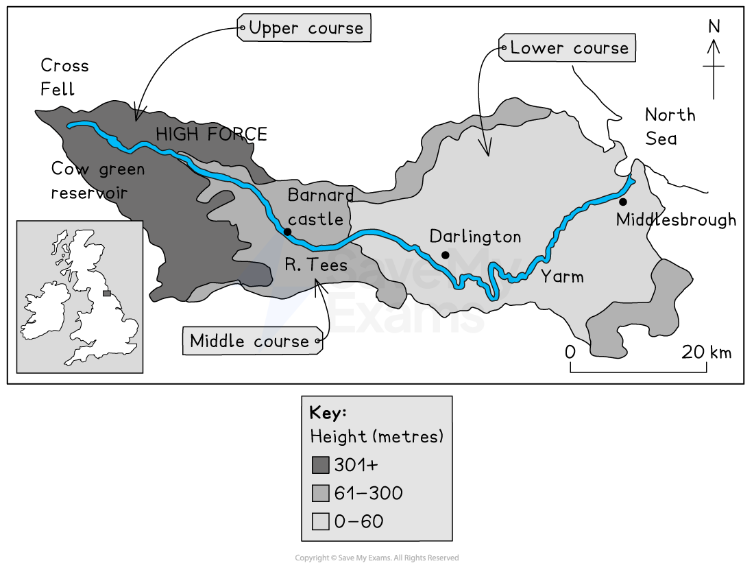
- Location - North-East England
- Drainage basin - 1830km2
- Source -Cross Fell, Pennines 754m above sea level
- Length - 137km
- Mouth - Tees Estuary, North Sea
- The direction of flow is from west to east
Map of River Tees Drainage Basin
Features of the River Tees
Upper course
The land use in the upper course is moorland, with peat soil
The land is mainly used for sheep grazing
It has an average annual precipitation of over 2000mm
The geology of the area is primarily limestone and sandstone
The river channel in the upper course:
- is narrow and shallow
- has a large angular bedload
- has high levels of friction
- is dominated by vertical erosion
- has a **steep gradient
Landforms in the upper course include:
- High Force waterfall where hard rock (dolerite also known as whinstone) overlies softer rock (limestone and** sandstone **)
- a steep-sided gorge which is left behind as the waterfall retreats upstream
- rapids
- v-shaped valleys created by vertical erosion
- interlocking spurs
Human activity in the upper course includes:
- Several dams and reservoirs, including Cow Green, were built to supply the urban areas to the east
- The dams also help to **control discharge **downstream
Middle course
The land use in the middle course is mainly farmland as the river valley widens
The number and size of settlements increase including Barnard Castle
The geology continues to be dominated by **limestone **and sandstone
Average annual rainfall decreases to approximately 1000mm
The river channel:
- increases in **width **and depth
- the** gradient** is more gentle
- bedload is smaller and more** rounded**
- experiences decreasing friction as less of the water is in contact with the banks and bed
- is dominated by lateral erosion
Landforms in the middle course include:
- **meanders **which develop due to the increase in lateral erosion
Lower course
The land use in the lower course includes:
- arable farming
- increasingly large settlements such as Middlesborough and Stockton on Tees
- industrial areas
Annual average rainfall decreases further to approximately 773mm
The river channel:
- increases in width and depth
- the** gradient** is very gentle
- bedload is now **small sediment
- is dominated by** lateral erosion** and then deposition nearer to the mouth where the river becomes** tidal**
Landforms in the lower course include:
- large meanders
- ox-bow lakes
- levees
- floodplains
There is lots of human activity in the lower course impacting the river channel and the surrounding landscape
Flood prevention schemes in Yarm and other settlements
The Tees Barrage which was built to prevent flooding at high tides
River straightening downstream of Stockton to allow easier navigation further up the river
- The Mandale Loop was a meander which was cut off to reduce the distance ships had to travel by 4km
Industrial developments on the floodplains close to the estuary
Was this revision note helpful?