Urban Land Use Patterns (Edexcel IGCSE Geography)
Urban Land Values
Spec point —
4GE1-S6.069
-
All urban settlements have recurring features:
- A central core or central business district (CBD)
- Industrial areas
- Different residential districts
- Shopping centres
- High-rise buildings
- Cultural and leisure areas
- Multi-storey car parks
- Bus and railway stations
-
These features have created segregated land use over time
Land values
-
Segregation of land use is due to the differences in urban land values
- Land that has 'purpose' will be valuable and cost more to buy or rent
-
Usually, retail shops can make money and seek prime positions
- Segregation is formed by retailers that can afford to be in those prime locations
- Therefore, land uses of similar activities will come together creating 'peaks' and 'troughs' of land values across the urban landscape
-
There are a couple of points to consider:
-
The value of the land:
- Land value varies across the urban areas
- Value usually decreases from the centre, outwards
- Higher land prices are also found along main roads, urban hubs and around ring roads
-
The location of the land:
- Location is important to value
- The closer to key functions, the higher the value
- Accessibility and desirability increase land value
-
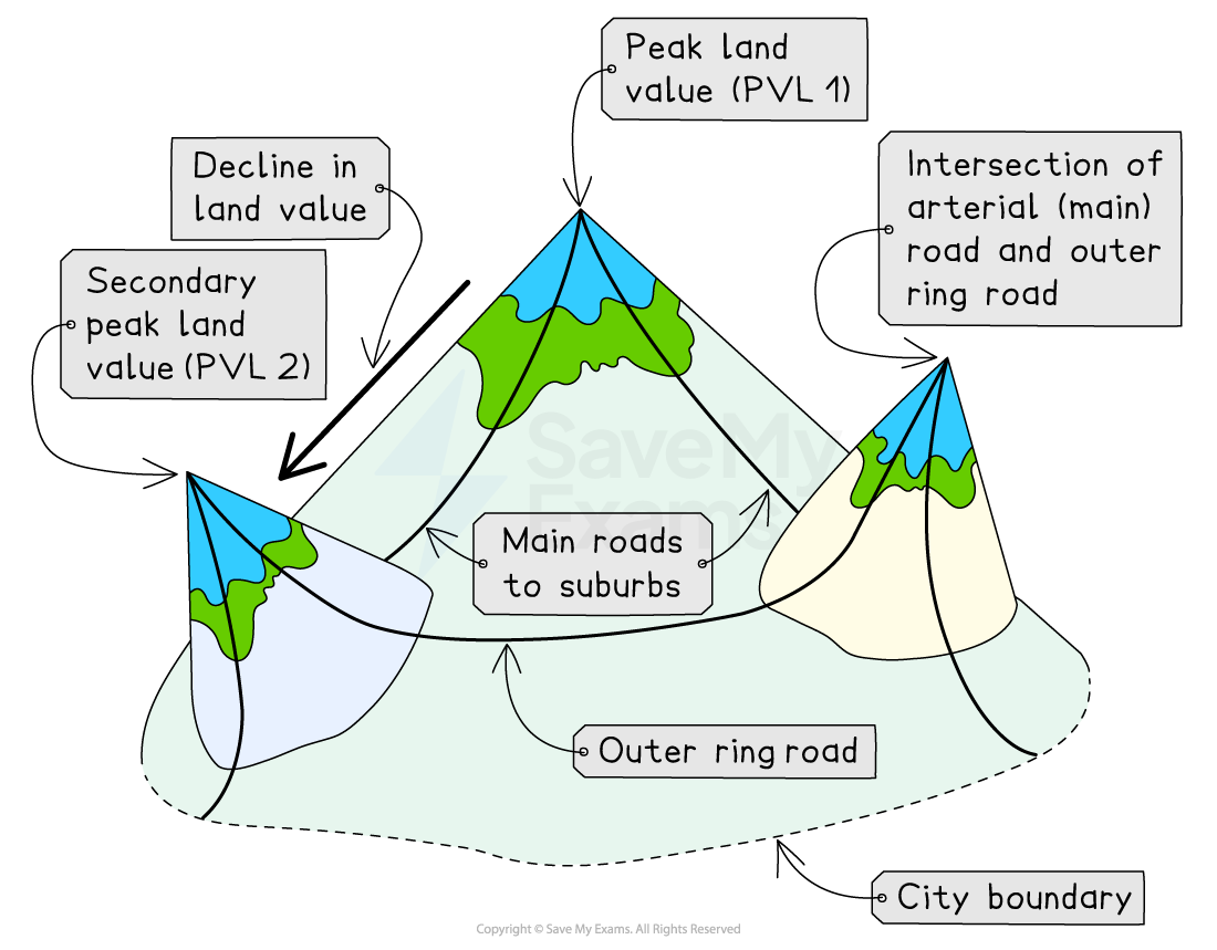
Distribution of urban land value
Patterns of Urban Development
Spec point —
4GE1-S6.069
-
Cities can be segregated into zones
-
Zones will have similar land values and locational needs, such as access for customers, employees, etc. or space for expansion or privacy
-
All towns and cities grow outwards, in a series of rings, from a historic centre or core to an urban fringe
-
Each zone grows due to the needs of the city during its development, over time
-
As a general rule, all towns and cities, regardless of place or level of development, show the same four features:
-
A central core: the oldest part of a city
- Home to the central business district (CBD) e.g. banks, retail and commercial offices
-
An inner-city ring: also known as the twilight zone
- Older, terraced 'worker' housing
- Older industrial areas
- Areas are centred around transport links and access
-
A suburban ring: residential area
- Semi- and detached housing with gardens
- Tree-lined avenues and cul-de-sacs
- Smaller retail premises
-
An urban fringe: outer edges of the city
- The countryside is eroded through the urban spread
- Housing is clustered into estates
- Some industrial land use
- Accessibility is best
-
-
Other similar characteristics of modern urban settlements include:
- The age of the built-up area decreases from the core to the fringe
- The density of building developments decreases from the core to the fringe
- Grandeur, function, design and style changes across the zones
Exam Hint
- Remember that whilst the four-zone model is simple and applies to virtually all urban areas across the globe, each zone varies in character, use and people depending on circumstances.
- In emerging cities, the urban fringe contains informal settlements or shanty towns that serve as 'housing estates', while industry remains informal.
- Whereas, in developed cities, the poorer areas are usually within the inner city, and industry is on the fringes for ease of access to motorways.
- Same features but different characteristics/uses.
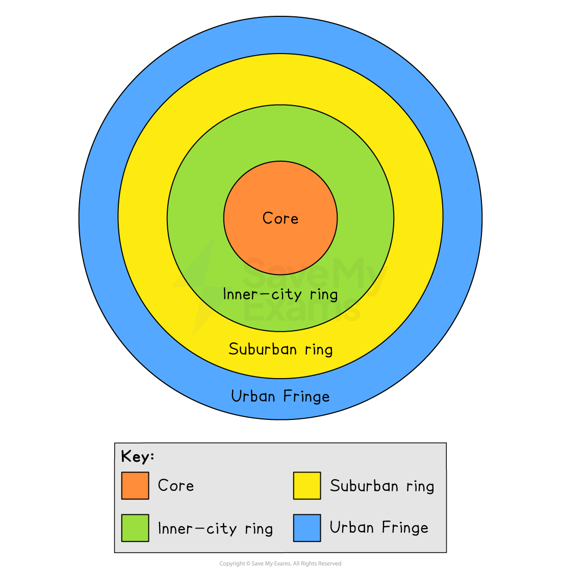
Four Zones of a City
Bid-rent theory
- Also known as 'distance decay theory', where the price and demand for land change as the distance from the CBD increases
- Different land uses will compete for desirable plots to maximise their profits
- Accessibility increases the potential for more customers
- There is a trade-off between accessibility and the cost of the land
- The closer to the CBD, the more desirable land is to retail and the higher the price charged/paid
- Industry cannot compete with high prices moving further away from CBD
- Residential land is outpriced across the zones, but competition is less so value decreases as more space becomes available
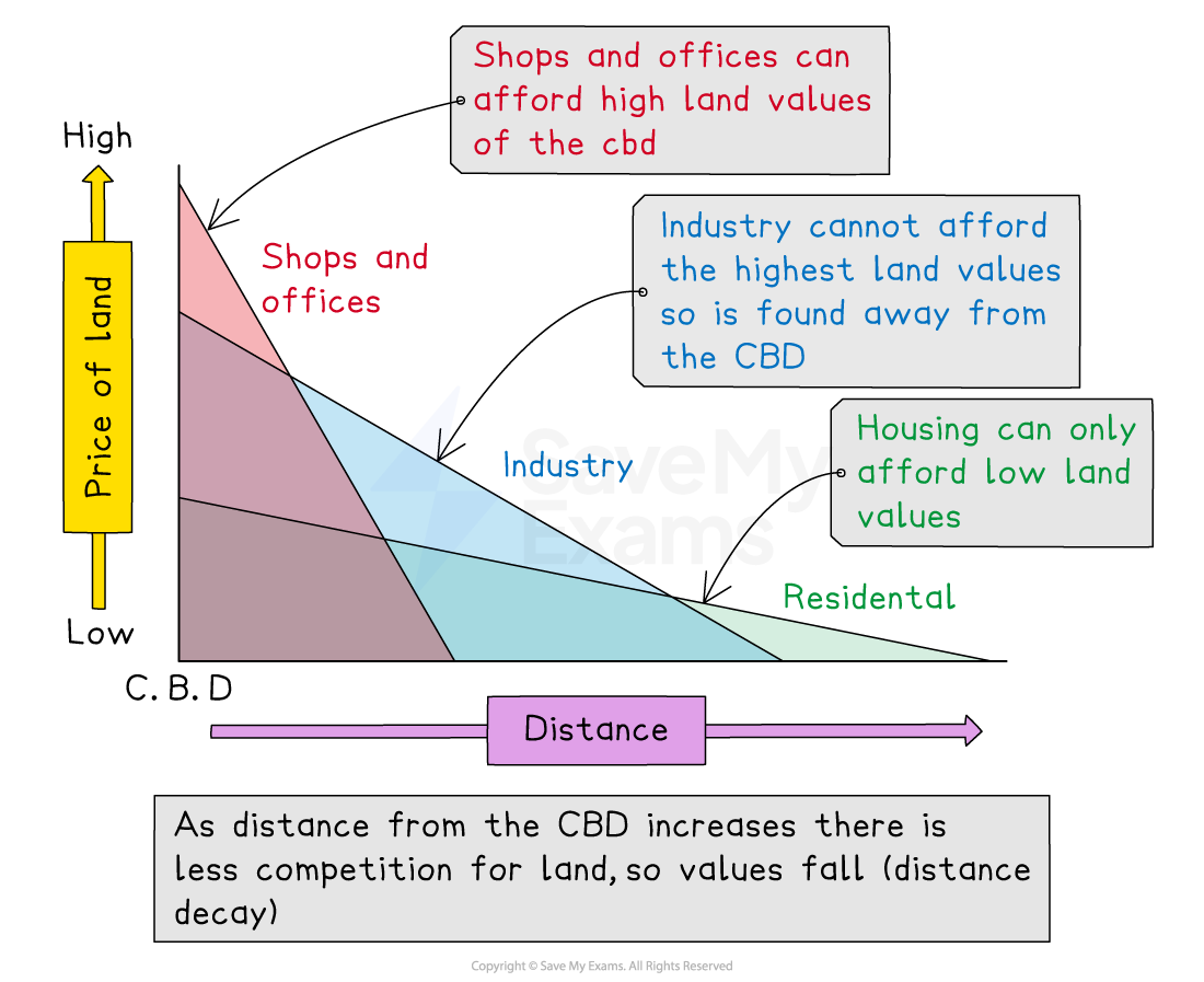
* Illustration showing bid-rent theory*
Residential Pattern
Spec point —
4GE1-S6.069
-
People are also zoned or 'sorted' within an urban area
-
People will live near other people who they consider the same
- This may be due to ethnicity, religion, occupation, etc.
-
This creates an urban pattern of self-organised segregation
-
The largest segregation is created through personal wealth
-
The wealthiest people can buy smart, large homes in the best locations
-
This forces the less well-off to live in cramped or sub-standard housing in the worst areas
-
Many have to pay high rental prices with little to no security
-
Due to their limited means, many are forced to live in small, cramped spaces creating high-density residential areas and unequal sorting across the urban area
Worked Example
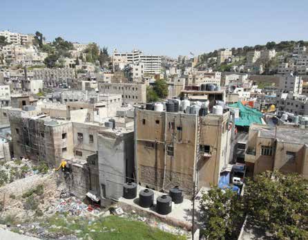
Study the photograph.
Explain one piece of evidence that shows this is a central urban area
(1 mark)
An urban area in Amman, Jordan
Answer:
- 1 mark for a piece of evidence, 1 mark for developing the point, e.g.
- The housing in the picture is very high density (1), which is typical of city areas where land values are high (1)
- The image shows multiple-storey houses (1) which are likely to house large numbers of people (1)
- There is little green space (1), indicating the built-up nature of the area since land values are so high (1)
Was this revision note helpful?