15 marksmedium
Describe how a wave-cut platform forms.
18 questions · 82 marks · ≈ 1 hour · spans 18 of 30 topics
Assembled from the topic question banks — not an official Cambridge International paperDescribe how a wave-cut platform forms.
Evaluate the different ways in which the impacts of tropical storms (cyclones, hurricanes and typhoons) can be managed.
Assess the impacts of deindustrialisation on people and places in HICs.
Assess the extent to which globalisation reduces the development gap.
State one reason why Antarctica is described as a polar desert.
Figure 3.1 shows four climatic regions
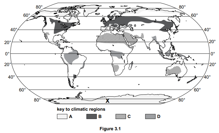
Zone D in Figure 3.1 has an equatorial climate. Describe the distribution of the regions with an equatorial climate.
Study Fig. 1.2, which is an extract about a guest worker from the Philippines who is living in Dubai in the UAE.
| Teresa Cruz is one of many millions of adults who have travelled thousands of miles from home to earn money to send back to their families. Teresa lives in Dubai, the UAE’s largest city, 7000 kilometres from her home country, the Philippines. She earns the minimum wage as an assistant at a clothing store in a shopping mall in Dubai. She works six days a week and Friday is her day off. On Friday at 12:00, it is time for Teresa to see her 11-year-old daughter and 8-year-old son who live with their aunt, who is raising them in the Philippines. As she is an overseas worker, she does this in the modern way. She pulls a stool up to a desk inside the small bedroom she shares with four other people. She logs on to the computer, clicks a video chat button and waits. Teresa lives in the bedroom with her husband, Luis, who, like Teresa, left the Philippines years ago. They decided that the only way to do the things a parent wants to do—pay for schoolbooks, make sure the grandparents in the Philippines have enough to eat, prepare the children for college one day—is to leave the family behind and find work in a distant country with a different language and culture. |
|---|
Fig. 1.2
Identify three difficulties Teresa faces as a guest worker in Dubai from Fig. 1.2.
Study Fig. 1.1, which shows information about the total world population since 1800 with estimates up to 2100.
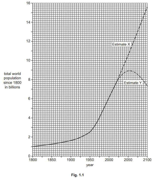
What was the total population of the world in 2020?
Extract:
Study Fig. 1.1, which shows information about the total world population since 1800 with estimates up to 2100.
Compare the growth of the world’s population from 1800 to 1950 with the growth between 1950 and 2020. Use statistics in your answer.
Study Figs. 1.2 and 1.3, which are population pyramids showing the structure of China’s population in 2010 and 2050 (predicted).
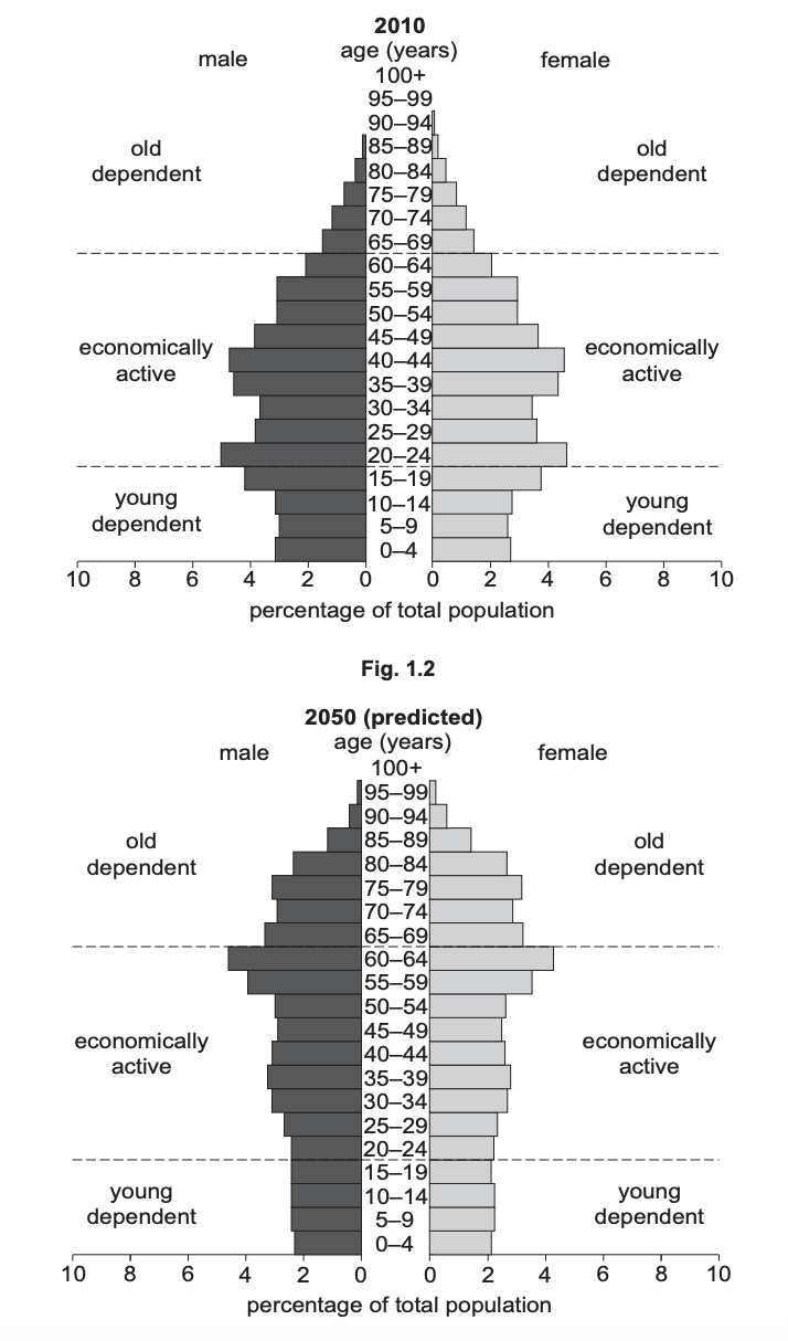
Fig 1.2 and 1.3
Describe the changes which are predicted in China’s economically active population between 2010 and 2050.
Suggest reasons why the amount of infiltration may vary .
Describe the hazards provided by a named river you have studied for people who live close to it
Named river ..............
Explain how transport strategies can make urban growth more sustainable. Use examples.
Study Fig. 2.1, a map showing urban zones in Bangkok, the capital city of Thailand (a country in Asia).
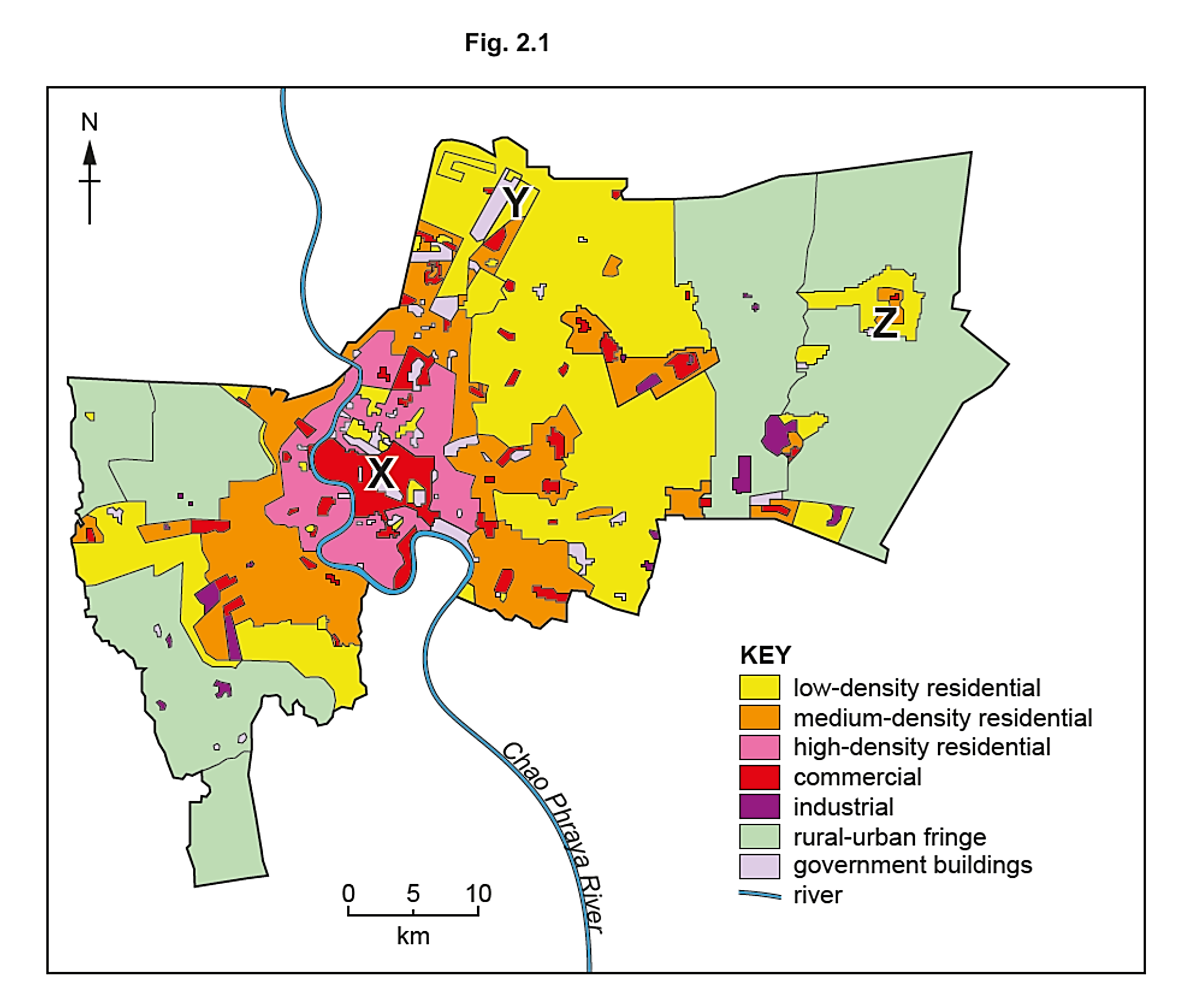
What is the direction from point X in the CBD of Bangkok to the government buildings at Y?
Extract:
Study Fig. 2.1, a map showing urban zones in Bangkok, the capital city of Thailand (a country in Asia).
Using Fig. 2.1, describe the location of the high-density residential zones in Bangkok.
Extract:
Study Fig. 2.1, a map showing urban zones in Bangkok, the capital city of Thailand (a country in Asia).
The residential area in the rural-urban fringe marked Z on Fig. 2.1 has been recently developed. Give three advantages to living on the rural-urban fringe.
Study the map extract showing part of Kingston, Jamaica (scale 1:50 000). Jamaica is an LIC.
Map extract
Kingston is an urban area. Define the term urban area.
Study Figs. 6.2, 6.3 and 6.4, which are photographs of economic activities which increase greenhouse gases in the atmosphere.
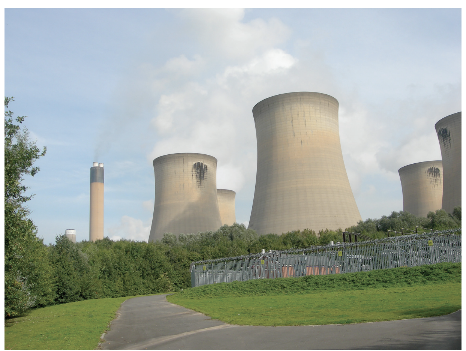
Fig 6.2
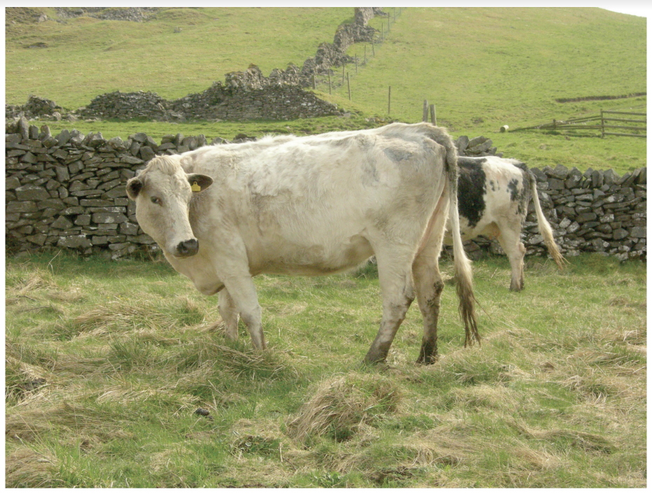
Fig 6.3
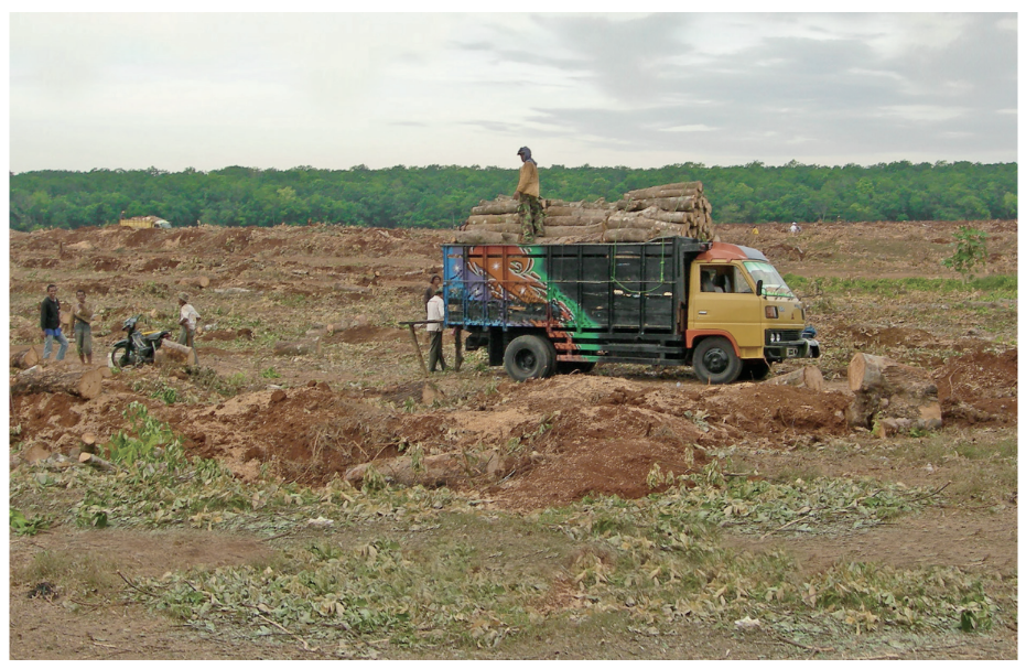
Fig 6.4
Explain how an increase in greenhouse gases in the atmosphere is causing global warming.
Study Fig. 5.1, a map showing the HDI of India’s states. India is an LIC in South Asia.
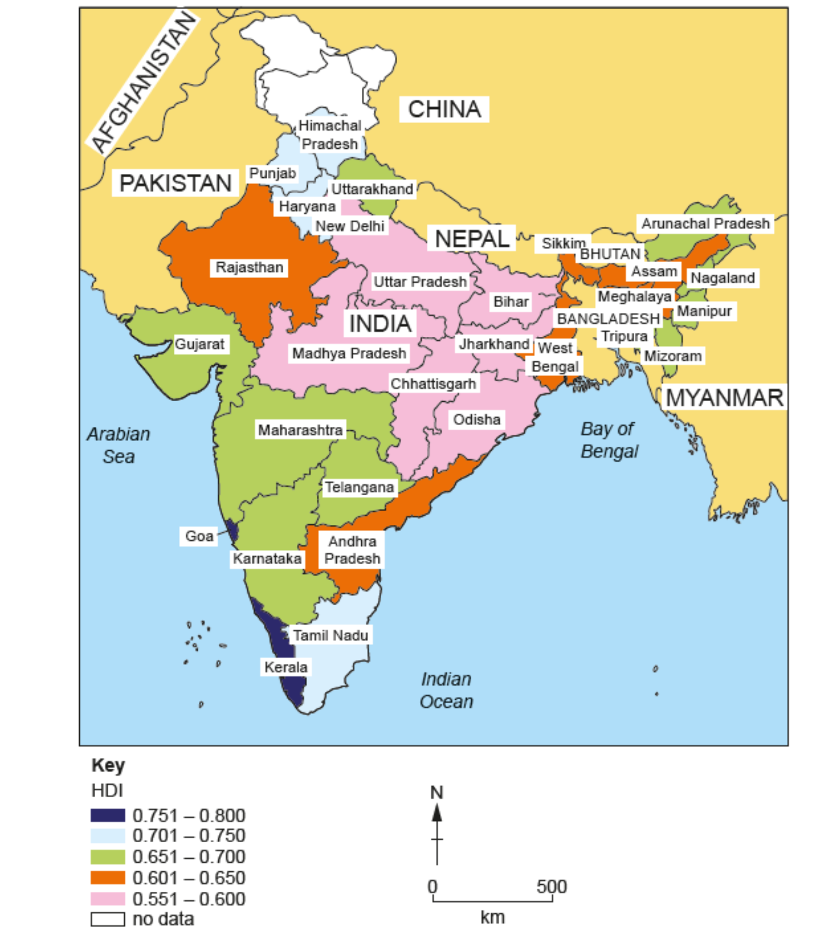
Fig. 5.1 HDI of India’s states
Using Fig. 5.1, name
a) an Indian state with an HDI of 0.551–0.600
b) a state in the east of India with an HDI of 0.651–0.700.
Evaluate whether top-down or bottom-up strategies are more effective in achieving sustainable development.
Assess the extent to which social factors explain uneven development between countries?