Coastal Management (Cambridge International IGCSE Geography)
Managing the Impacts of Coastal Erosion
Spec point —
2.3.5· Explain what can be done to manage the impacts of coastal erosion
- There are conflicting views about what type of engineering to use for coastal defence
- Most coastal managers aim to use a range of methods depending on the value of what is being protected
- This method is known as Integrated Coastal Zone Management (ICZM)
- ICMZ aims to use a combination of methods to best reflect all stakeholder's needs
Soft engineering methods
- Soft engineering works with natural processes rather than against them
- Usually cheaper and do not damage the appearance of the coast
- Considered a more sustainable approach to coastal protection
- However, they are not as effective as hard engineering methods
Soft-engineered defences
Beach replenishment
-
This is the pumping or dumping of sand and shingle back onto a beach to replace eroded material
-
Advantages
- Beaches absorb wave energy
- Widens beachfront
-
Disadvantages
- Has to be repeated regularly, which is expensive
- Can impact sediment transportation down the coast
Fencing, hedging, and replacing vegetation
-
Helps to stabilise sand dunes or beaches
-
Reduces wind erosion
-
Advantages
- Cheap method to protect against flooding and erosion
-
Disadvantages
- Hard to protect larger areas of coastal cliffs
Cliff re-grading
-
This is when the angle of a cliff is softened to reduce mass movement
-
Advantages
- Prevents the sudden loss of large sections of cliff
- As wave energy is slowed, wave-cut notching is reduced at the base of the cliff
-
Disadvantages
- It does not stop cliff erosion; it only slows it down
Beach re-profiling
-
Beach reprofiling is the artificial re-shaping of a beach using existing beach material
-
Advantages
- Replaces shingle after winter storms
- Increasing the profile reduces wave energy before the base of the cliffs
-
Disadvantages
- Reprofiling may have a negative effect on beach habitats
Managed retreat
-
The existing coastal defences are abandoned, allowing the sea to flood inland until it reaches higher land or a new line of defences
-
Advantages
- There are no expensive construction costs
- Creates new habitats such as salt marshes
-
Disadvantages
- Disruptive to people where land and homes are lost
- The cost of relocation can be expensive
- Full compensation to people and businesses may not be paid
Hard engineering methods
- Hard engineering involves building concrete, wood, or rock sea defences
- Building and maintaining structures is costly
- Defences work against the power of the waves
- Each defence has pros and cons
- Protection in one place can increase erosion and flooding along the coast
- When settlements and expensive installations (power stations, etc) are under risk, hard engineering is used because the economic gain outweighs the costs
Hard-engineered defences
Sea wall
-
A sea wall is usually concrete and curved outwards to deflect the power of the waves
-
Advantages
- Most effective at preventing both erosion and flooding (if the wall is high enough)
-
Disadvantages
- Very expensive to build and maintain
- It can be damaged if the material in front of the wall is not maintained
- Restricts access to the beach
- Unsightly to look at
Groynes
-
These are wood, rock or steel pilings that are built at right angles to the shore
-
Longshore drift moves beach material into groynes
-
Advantages
- Most effective at preventing both erosion and flooding (if the wall is high enough)
-
Disadvantages
- Keeps material from moving down the coast and protects cliff bases elsewhere
- Starves other beaches of sand
- Wooden groynes need maintenance to prevent wood rot
- Makes walking along the shoreline difficult
Rip-rap or rock armour
-
Large boulders are piled up to protect a stretch of coast
-
Works to absorb wave energy from the base of cliffs and sea walls
-
Advantages
- Cheaper method of construction
-
Disadvantages
- Boulders can be eroded or dislodged during heavy storms
Gabions
-
Wire cages are filled with stone, concrete, sand, etc.
-
Cages absorb wave energy
-
Advantages
- Cheapest form of coastal defence
- Can be stacked at the base of a sea wall or cliffs
-
Disadvantages
- Wire cages can break, and they need to be securely tied down
- Not as efficient as other coastal defences
Revetments
-
Sloping wooden or concrete fence with an open plank structure
-
Revetments work to break the force of the waves
-
Advantages
- Traps beach material behind them
- Set at the base of cliffs or in front of the sea wall
- Cheaper than sea walls but not as effective
-
Disadvantages
- Not effective in stormy conditions
- Can make beach inaccessible for people
- Regular maintenance is necessary
- Visually unattractive
Off-shore barriers
-
Large concrete blocks, rocks and boulders are sunk offshore to alter wave direction and weaken wave energy
-
Advantages
- Beach material is built up
- Low maintenance
- Maintains natural beach appearance
-
Disadvantages
- Expensive to build
- Can be removed in heavy storms
- Can be unattractive
- Prevents surfing and sailing
Prediction
-
Early warning systems allow communities to prepare (evacuate or take shelter) before flooding occurs
-
Two methods are used to help forecast coastal flooding
-
Past records: diaries, newspapers, government/council records, etc.
-
These identify areas that are at high risk of flooding and their frequency
-
Modern technology: GIS, satellite and computer monitoring, weather stations (local and national), etc.
-
These forecast and track potential hazardous events such as:
- Tropical storms: track the storm's path and associated storm surge
- Earthquakes: the size and position of underwater tremors and possible tsunami outcome
-
-
Both forecasting methods help officials determine when and where the event will occur
-
They shows the risk of damage and fatalities as well as the potential intensity and scope of the flooding
Prevention
- Prevention is about taking action that reduces or removes the risk of coastal flooding
- Actions include:
Flood defences
- These are built along high-risk stretches of coast
Emergency centres
- Centrally placed on higher ground where people can be safe from flooding
Early warning systems
- Allows for preparation or evacuation of an area
Education
- Informing local people on what to do if and when a flood occurs
Planning
-
Any new development should be planned away from high-risk-areas
-
Design buildings to deal with low levels of flooding
- Raise buildings to allow floodwaters to flow underneath
- Strengthen barriers
- Sealing a property to prevent floodwater intrusion is known as dry floodproofing
- Wet floodproofing allows some flooding of the building
Buffer zones
-
Areas of land are allowed to flood before reaching settlements
- This slows down the floodwater's journey by allowing the surge's energy to dissipate
- It can mean moving people away from the coast, which could be controversial
Coastal strategies
-
Management of coastal regions is performed by identifying coastal cells
-
This breaks a long coastline into manageable sections and helps identify two related risks:
- The risk of erosion and land retreat
- The risk of flooding
-
Identifying risks allows resources to be used efficiently to limit their impacts
-
The 'cost to benefit' is easier to calculate using coastal cells
Shoreline management plans
- Shoreline management plans (SMPs) outline strategies to prevent flooding and erosion along a coastline
- The strategies try to limit the risk to people, settlements, agricultural land, and natural habitats (such as salt marshes)
- There are four ways to manage coastal areas, each with different costs and consequences
Hold the line
- This is a long-term approach and the most costly
- It involves building and maintaining coastal defences to keep the current position of the shoreline
- Dominated with hard engineering with soft engineering supporting it
Advance the line
- New defences are built to extend the existing shoreline
- Involves reclaiming land
- Hard and soft engineering is used
Managed realignment
- The coastline is allowed to move naturally
- Processes are monitored and directed when and where necessary
- The most natural approach to coastal defence
- Mostly soft engineering with some hard engineering to support
Do nothing
-
The cheapest method, but also the most controversial of the options
-
The coast is allowed to erode and retreat inland
-
No investment is made in protecting the coastline or defending against flooding, regardless of any previous intervention
-
Decisions about which approach to use are complex and depend on:
- Economic value of the resources that would be protected, e.g. land, homes, etc
- Engineering solutions: it might not be possible to 'hold the line' for moving landforms such as spits or unstable cliffs
- Cultural and ecological value of land: historic sites and areas of unusual diversity
- Community pressure: are there any local campaigns to protect the region?
- The social value of communities: long-standing, historic communities
Worked Example Explain how gabions protect the coast
[2 marks]
Solution
Gabions absorb/dissipate/reduce the wave's energy/power [1 mark]. This reduces the impact of the waves at the foot of cliffs and seawalls, which reduces/prevents coastal erosion [1 mark].
Marking guidance
The command word here is 'explain,' and answers need to be developed for full marks.
- 1 mark for identifying the purpose
- 1 mark for development
Case Study - Super Typhoon Haiyan
Spec point —
2.3.5· The opportunities presented by an area, or areas of coastline, the associated hazards and their management
Case Study: Super Typhoon Haiyan
- Managing tropical storms is difficult due to the unpredictability of their paths
- The distribution of the population along a coast increases the risk associated with tropical storms
- The strength of the storm does not always cause the most damage; developing countries are usually the worst affected
- Preparedness is an effective way of managing tropical storms
- Hazard mitigation relies on effective response to natural events
Background
- Typhoon Haiyan (Yolanda) was one of the strongest tropical storms to hit the Philippines
- It made landfall on November 8, 2013, as a Category 5 with sustained winds above 195 mph
- The Philippines are a group of South China Sea islands located east of Vietnam and north of Indonesia
- Southwest typhoons regularly sweep in every tropical storm season
- Even though the islands sit in warm ocean water, the storm's sea temperature at the time was 30 °C
- Since 1900, sea levels have risen 20 cm around the world. Higher seas are known to contribute to stronger storm surges
- Over-abstraction of groundwater has caused parts of the country to sink
- Tacloban stands at the end of a bay that is funnel-shaped and this squeezes water into destructive storm surges
Formation of tropical storms
-
All tropical storms need:
- warm, deep water (>27°C and >70 m depth)
- sufficient spin from the earth’s rotation (Coriolis force)
-
This is why they form between 5-20° N and S of the equator
-
Warm water encourages sea surface evaporation, while rising air cools, condenses, releases latent heat, and produces large thunderclouds
-
The heat from below produces vertical growth and intense low-pressure
-
Tropical storms form when several storms merge at the eastern side of an ocean
-
A major low-pressure cell develops and as winds are drawn in, the whole system begins to spin anticlockwise and westward
-
Winds rotate around a central eye, where cold air descends, creating an area of calm
-
The strongest winds are within the eyewall
Typhoon Haiyan's timeline
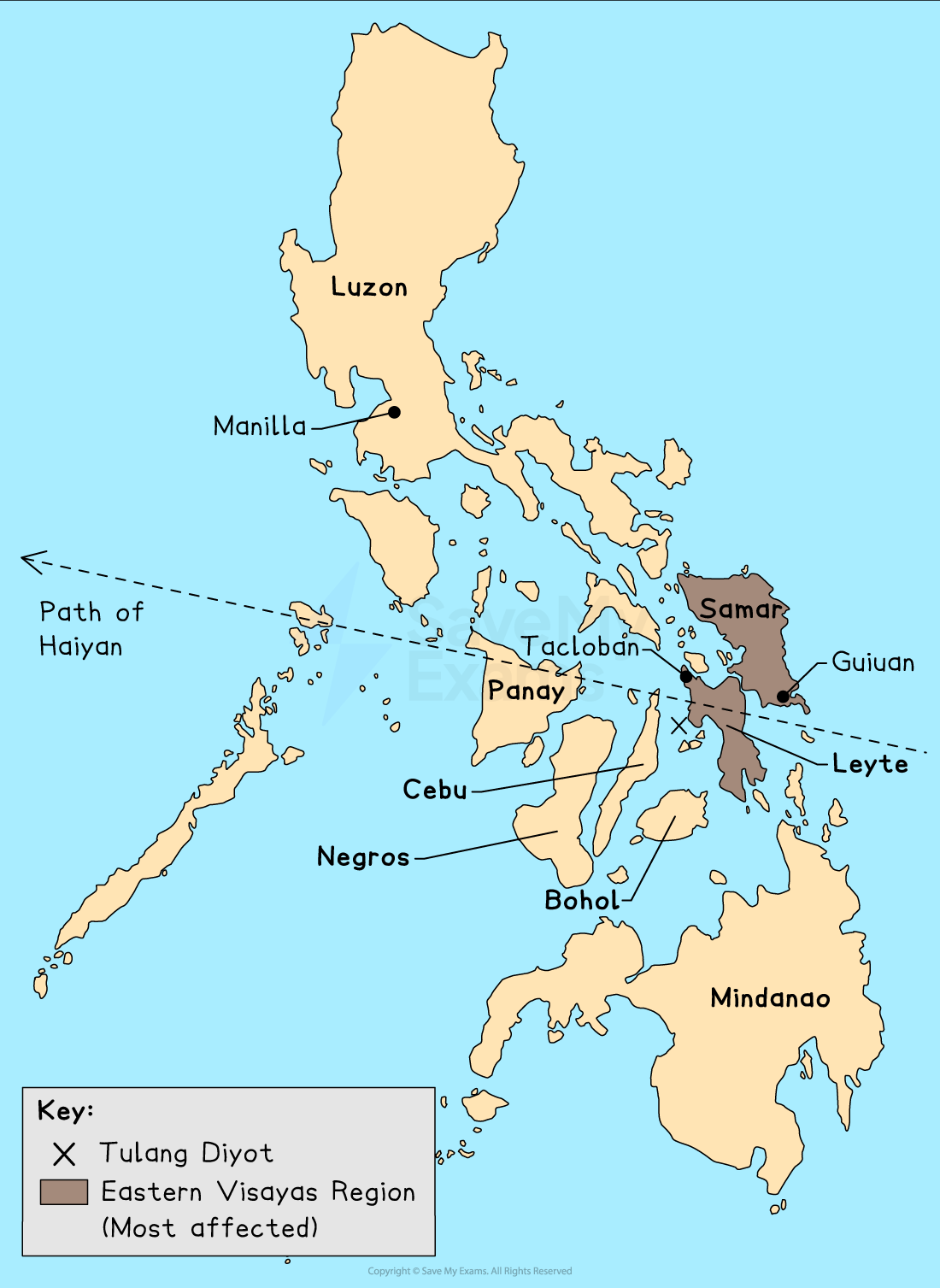
Path of Typhoon Haiyan November 2013
Nov 2013
- 2nd: an area of low pressure develops several hundred kilometres east of Micronesia
- 3rd: Haiyan begins to track westward, deepening into a tropical depression
- 5th: The Philippines Atmospheric, Geophysical, and Astronomical Services Administration (PAGASA) classified it as a typhoon and issued a low-level public storm warning
- 6th: declared a Category 5 super typhoon by the Joint Typhoon Warning Centre. PAGASA raises storm warning to highest level, indicating expected wind speeds in excess of 115 mph
- 7th: Haiyan's winds continue to intensify up to 195 mph. Haiyan makes first landfall at Guiuan, Eastern Samar, without losing any intensity
- 8th: Haiyan makes five more landfalls within the Philippines before passing into the South China Seas
- 10th: Haiyan turns to the NW and makes landfall in Northern Vietnam as a Category 1 typhoon
- 11th: Haiyan finally weakens into a tropical depression
Typhoon Haiyan's characteristics
- Lowest pressure: 895 mb
- Peak strength: category 5
- Strength at landfall: Category 5 with 195 mph winds
- Highest sustained wind speed: 196 mph
- Radius of typhoon strength winds: 53 miles
- Rainfall: 400 mm
- Storm surge height: 15 m
Preparation for Typhoon Haiyan
- Despite being an LEDC, the Philippines take disaster preparedness seriously, as they are usually the first Pacific landmass to experience a typhoon
- For decades, the Philippines have practiced risk reduction and resilience, publishing risk maps and providing evacuation shelters
- The International Charter on Space and Major Disasters was triggered when Haiyan made landfall, allowing relief agencies to get satellite data from space agencies to aid recovery
- The military deployed planes and helicopters in advance to areas expected to be worst hit
- Community structures like conference centres were designated storm shelters, but there were concerns they would not withstand the wind
- After years of community preparation and education, entire islands like Tulang Diyot were evacuated, with all 1000 residents evacuating before Haiyan
- The local mayor won an award in 2011 for community work based on the 'Purok system', in which community members agree to deposit their own money into a community fund regularly for post-disaster help rather than waiting for government relief
Impacts of Haiyan
Short- and long-term impacts
Social
-
Short-term
- 6201 people died
- 1.1 million homes lost
- more than 4 million displaced
- Casualties: 28,626 from lack of aid
- 16 million people affected
- UN admitted its response was too slow amid reports of hunger/thirst among survivors
-
Long-term
- UN feared the possibility of the spread of disease, lack of food, water, shelter and medication
- Areas less affected; an influx of refugees into the area
- 21,000 families were still in 380 evacuation centres two months later, waiting for the government to build bunkhouses to house them in
Economic
-
Short-term
- Estimated at $13 billion
- Major sugar/rice-producing areas were destroyed
- Between 50,000 and 120,000 tonnes of sugar were lost
- Over 130,000 tonnes of rice were lost
- government estimated that 175,000 acres of farmland was damaged (worth $85 million)
-
Long-term
- The Philippines declared 'a state of national calamity.’
- Asked for international help the next day
- President Aquino was under growing pressure to speed up the distribution of food, water, and medicine
- Tacloban city was destroyed
- Debt is a major obstacle for the Philippines; the country is locked in a debt cycle, with more than 20% of government revenue spent on foreign debt repayments
Environmental
-
Short-term
- Loss of forests and trees, and widespread flooding
- Oil and sewage leak into local ecosystems
- Lack of sanitation in the days following led to a higher level of pollution
- Coconut plantations were said to be 'completely flattened' (coconut equated to nearly half of the Philippine's agricultural exports and is the world's biggest producer of coconut oil)
- Fishing communities were severely affected
-
Long-term
- Small-scale farmers make up 90% of typhoon-affected rural populations
- After 33 million coconut trees were cut, international help was sought to mill the 15 million tonnes of rotting lumber that attracted pests that threatened healthy trees
- Families lack funding for local marketplaces without crops
Immediate relief
- The survivors immediately searched flattened buildings for bodies
- People began looting to find food supplies when the government was slow to respond
- Roads were undamaged, but debris slowed rescue vehicles
- Emergency teams were slowed as airports and harbours were closed, which hampered aid distribution
- Diggers, land rovers, and heavy lifting gear from the UK and USA were sent to Tacloban airport by international charities
- The European Commission released $4m in emergency funds and the UK Rapid Response Facility provided $8m in aid
- Twelve IFRC (International Federation of the Red Cross) Emergency Response Units worldwide were deployed
- The Philippines had already experienced a 7.3-magnitude earthquake in October 2013 and Typhoon Bopha in 2012. These tragedies left the Philippines short on financial, material, and human resources
Was this revision note helpful?
Build on this topic